Illinois scientists revisit 165-year-old soil sample to uncover history of land use
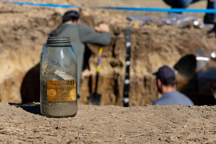
In 1861, a scientist collected a soil sample from native prairie near what is now Tamaroa, Illinois. The prairie has since become farmland, and the surrounding landscape has undergone generations of agricultural development. But a jar of soil preserved at the University of Illinois Urbana-Champaign offers researchers a rare opportunity to find out what has changed beneath the surface.
The specimen is the oldest known sample in a collection of more than 8,000 historical soils rediscovered by Andrew Margenot, professor in the Department of Crop Sciences, part of the College of Agricultural, Consumer and Environmental Sciences (ACES) at U. of I. The archive includes samples from hundreds of locations across Illinois, some collected before modern agricultural practices transformed the state's landscape. Supported by Illinois Nutrient Research and Education Council (NREC), Margenot’s team has been resampling the over 460 original locations across Illinois, to improve understanding of legacy nutrients and general changes in soil fertility relevant to agriculture and environmental quality today.
Scientists are now able to compare the historical soils with present-day soils, investigating changes in fertility, erosion and other properties that influence agricultural productivity and conservation. Importantly, these comparisons are being made on the full “profile” — the entirety of the soil and its layers from the surface to 36” depth, or lower.
The latest work brought researchers back to Perry County, where the 1861 sample originated. With help from retired soil scientist Sam Indorante and the U.S. Department of Agriculture's Natural Resources Conservation Service (NRCS), the team located the historical sampling area. Indorante and NRCS soil scientist Mindy Siner used historical maps, land records and descriptions of the original sampling area to identify a representative location. The effort required accounting for changes to the landscape, including a road that followed a different route in the 19th century.
The researchers first resampled the soil in December 2025, and returned in 2026 for a more detailed examination of the soil, excavating a pit that exposed layers extending several feet beneath the surface. The gathering brought together current and retired soil scientists, local landowners and conservation officials to document the site and its significance.
"We know that it was 1861 when it was originally sampled, so we come back and we're like opening up the time capsule and looking at the soil, the different soil properties, the different soil layers, to see the changes that have occurred," Indorante said.
The original sample represented only the upper 6 inches of soil. The new investigation examines the entire soil profile, providing a more complete picture of how the soil formed and how its properties may have changed under cultivation.
Siner identified several distinct layers, including a dark surface horizon, a lighter layer beneath it and a dense clay layer characteristic of many southern Illinois soils. She also observed plate-like soil structures near the surface that she attributed to compaction from past agricultural management.
Those observations offer clues about the soil's history, although laboratory comparisons with the historical sample will be needed to establish the extent of changes over time.
Kevin McSweeney, a soil scientist in ACES, said each layer preserves evidence of the conditions under which the soil developed.
"Each one of those is like a chapter in a book, telling you the history," said McSweeney, clinical professor in the Department of Natural Resources and Environmental Sciences.
That history extends well beyond the arrival of agriculture. Windblown sediment deposited during past glacial periods helped form the soil, while differences in color, texture and structure offer evidence of water movement and vegetation.
The project also reconnects several generations of Illinois soil scientists whose careers have been shaped by the region.
Indorante and McSweeney studied prime farmland reclamation at Illinois in the late 1970s under soil scientist Ivan Jansen. Their work brought them to southern Illinois at a time when surface coal mining was raising concerns about the loss and restoration of productive farmland.
Perry County officials prioritized a detailed soil survey to guide land use and reclamation. Indorante subsequently joined the effort, working with two other soil scientists to map the county's approximately 283,000 acres.
That work became part of a statewide soil survey system that today informs decisions about agriculture, conservation, construction and development. But while soil maps document the distribution and characteristics of soils, they cannot necessarily show how those properties have changed over generations.
The historical archive offers a way to investigate that question directly.
Margenot's broader project seeks to resample hundreds of locations represented in the university's collection, comparing soils collected decades or more than a century apart. The findings could improve understanding of how agricultural management has affected Illinois' soil resources and help inform future conservation and fertility recommendations.
For Indorante, who has spent more than five decades studying soils, the return to Perry County represents both a scientific opportunity and a continuation of work begun by earlier generations.
"We've dedicated our lives, our professional lives, to soil, soil conservation, good land use, water quality, air quality, and the parts the soil plays," he said. "But it makes me very proud that we're moving it forward still."
The results of the new analyses are still to come. For now, the researchers have reunited a 165-year-old scientific record with the landscape from which it came, opening another chapter in the history of Illinois soils.